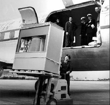
5MB IBM Hard Drive in 1956
5MB IBM Hard Drive in 1956
 Computers, Hi-Tech & Product Reviews Technology
 Go | New | Find | Notify | Tools | Reply |
| Any GPS that can print maps/waypoints plotter size?? | Login/Join |
one of us |
All, At my hunt club, we have several properties. I'd like to use a GPS to record each of the tree stands as waypoints, then print them out on plotter to hang in the clubhouse. If could inport and overlay on a google map or some other type of image, that would be ideal. I am assuming these can be converted from GPS to computer file, but maybe that's a bad assumption. I may later laminate and then have folks write name on each for check in/check out daily. Does anyone have experience using a GPS for this type of use? If so, best GPS to use to accomplish? Thanks for the help. Brad | ||
|
| Powered by Social Strata |
| Please Wait. Your request is being processed... |
Computers, Hi-Tech & Product Reviews Technology

Visit our on-line store for AR Memorabilia